Why Pantai Drini Offers Two Different Coastal Experiences
Pantai Drini's rocky outcrop separates different parts of the shore. Understanding that layout helps visitors read the landscape without assuming the sea is always calm.
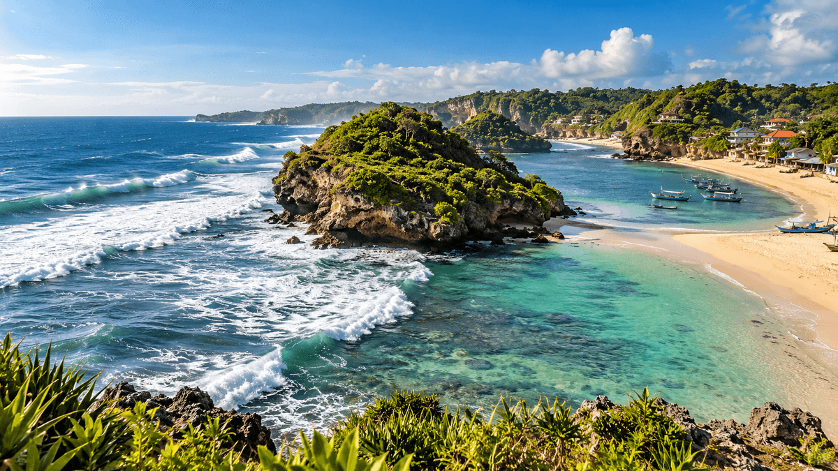
A small outcrop changes how the beach is experienced
Pantai Drini is more than a single, uniform stretch of sand. A rocky outcrop near the shore divides the beach into eastern and western sections, giving the area a distinctive spatial layout. The Gunungkidul Regency Government describes the eastern side as generally calmer and the western side as more exposed to waves, while the Kalurahan Banjarejo government identifies the western side as the area used by fishers and the location of the fish auction site. (Gunungkidul Regency Government (opens in a new tab); Kalurahan Banjarejo, March 4, 2024 (opens in a new tab))
These descriptions are useful for orientation, not a guarantee about conditions on any particular day. The coast remains exposed to changing tides, swell, wind, and weather. Visitors should assess the conditions they actually encounter and follow local instructions.
The eastern side: recreation depends on the day's conditions
The village government reports that the eastern side has a sandy shoreline and relatively calm water at times, and that local tourism groups have offered small-boat or canoe rentals there. (Kalurahan Banjarejo, March 4, 2024 (opens in a new tab)) That makes the area relevant to visitors who want to spend time near the water rather than only look at it from the shore.
Still, the phrase “relatively calm” is comparative, not a safety certification. Before entering the water or renting a canoe, look for current operator instructions, ask about weather and tide conditions, and stay inside any designated activity zone. If conditions are unclear, choose a land-based activity instead.
The western side: a beach and a working landing area
The western side is also part of the visitor landscape, but it serves a different function. The village government identifies this part of Pantai Drini as a fishing area with a Tempat Pelelangan Ikan (TPI), the local fish auction site. Visitors may be able to buy fish landed by local fishers, depending on what is available. (Kalurahan Banjarejo, March 4, 2024 (opens in a new tab))
This distinction matters in practice. A boat landing point is a workplace first and scenery second. Avoid walking through loading areas, touching equipment, or standing where boats and goods need to move. Ask before photographing people engaged in work, and do not assume that every activity is staged for visitors.
The rocky divider is a viewpoint with boundaries to respect
The village government says a bridge provides access toward the small hill or rocky outcrop and that the area is popular for photographs. (Kalurahan Banjarejo, March 4, 2024 (opens in a new tab)) The outcrop helps explain the beach's layout: it is a physical feature that shapes sightlines and separates two different uses of the shore.
Access can change because of weather, tide, maintenance, or local restrictions. Do not climb beyond marked routes, cross wet rocks simply to reach a photo angle, or treat a bridge as proof that all nearby terrain is safe. Check conditions on the day.
Why older descriptions sometimes sound different
Government descriptions of Drini do not use identical language for the west side's water conditions. One calls it more wave-exposed; the village article describes the shore and water as relatively calm while emphasizing its fishing function. These statements may reflect different observation dates, conditions, or a broad comparison with nearby sections; the available sources do not establish a single permanent state for the water.
The sensible conclusion is not to choose whichever description sounds more reassuring. Treat these pages as background on the beach's layout, then use current local information to decide what activities are appropriate.
How to experience both sides thoughtfully
Walk the shore before committing to an activity. Observe where boats are operating, note any boundaries posted by operators, and ask local staff where visitors should and should not go. If you are interested in the fishing economy, visit the TPI without interrupting work. If you plan to canoe, check equipment and current conditions first. If the sea is rough or access is restricted, enjoy the landscape from an appropriate viewpoint instead.
Pantai Drini's defining feature is the relationship between its rocky divider, its visitor-facing shoreline, and its active fishing area. Understanding that relationship makes the visit richer, and less likely to turn a working coast into a backdrop that ignores the people who use it every day.
Sources consulted
- Gunungkidul Regency Government, “Pantai Drini,” July 30, 2020. https://gunungkidulkab.go.id/pantai-drini/ (opens in a new tab). Checked October 25, 2026.
- Kalurahan Banjarejo, “Pantai Drini, Ikon Wisata Alam Utama Kalurahan Banjarejo,” March 4, 2024. https://desabanjarejo.gunungkidulkab.go.id/first/artikel/1968-Pantai-Drini--Ikon-Wisata-Alam-Utama-Kalurahan-Banjarejo (opens in a new tab). Checked October 25, 2026.
Keep reading
This article is part 3 of 11 in the series "The Pantai Drini Series".
- Previous: Building Economic Resilience Beyond Holiday Seasons in Gunungkidul
- Start of the series: How to Spend a Day in the Pantai Drini Area Without Rushing
Related articles: